The BC Wildfire Service is asking you to stay out of the area where the Briggs Creek wildfire is burning, about 11.5 kilometers west of Kaslo.
They’ve implemented an area restriction order, which they say “reflects the continued need to protect the public in areas where ongoing fire suppression activities are taking place.”
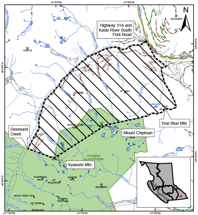
The order is in effect until Oct. 15 or until rescinded. The exact area is as follows:
Commencing at the junction of Highway 31A and Kaslo River South Fork Road, following the road along Keen Creek west then south to Desmond Creek up to the height of land then southeast to the peak of Kyawats Mountain.
From the peak of Kyawats Mountain, east to Mount Chipman, then east to True Blue Mountain, following the ridgeline north down to Kemp Creek confluence, following west of highway 31A back to the point of commencement at the junction of Hwy 31A and Kaslo River South Fork Road.
A better map can be found here: http://ow.ly/lAqG50KbURW
Travel along Kaslo River South Fork Road that follows Keen Creek is not permitted. Fourteen homes on that road are on evacuation alert. The fire, which was reported Monday, sits at 1,680 hectares. You can see it clearly from Kaslo, but BC Wildfire describes it as a smouldering ground fire that is burning slowly.
Nine firefighters and one helicopter are assigned to the blaze, but its steep terrain won’t allow for the use of heavy equipment.
A public information meeting on the fire is slated for 5 p.m. today at the Kaslo Legion.


